The South Banat administrative district is located in the southeastern part of the Autonomous Province of Vojvodina, which is at the north of the Republic of Serbia. It is bordered by the rivers Danube and Tamis, in the east by the state border with the Republic of Romania, while in the north the district borders with the municipalities of the Central Banat District - Secanj and Zrenjanin. It covers an area of 4 245km2.
The South Banat District includes 94 settlements, with 293,370 inhabitants (2011 census). The largest density of population is in the municipality of Pancevo (165 inhabitants per km2). Agricultural areas cover 80.9% of the territory, while under forests is 5.4%. The administrative and industrial center of the district is the City of Pancevo.
The name Banat stems from the word “ban” (denotes a ruling title), ie. It was named after the historical province called Timisoara Banat. The traditional symbol of Banat is lion, which is today on the coat of arms of Vojvodina and the coat of arms of Romania.
The geographical position, with an altitude of mostly 70-100 m, provides favorable conditions for agricultural production.
The Development Strategy of AP Vojvodina 2014-2020 defines strategic priorities as well as measures for their achievement. In accordance with this document, all cities and municipalities in the district drafted their own local development strategies, including measures for achieving the defined priorities.
Priority 1. Development of human resources
Measures:
1.1. Encouraging re-employment of people who have recently lost their jobs;
1.2. Increasing the employability of unemployed persons and especially vulnerable categories on the labor market (persons with disabilities, long-term unemployed, Roma, youth, highly educated, young, talented persons ...);
1.3. Improving the employability of labour force by enhancing their expertise through modernisation of the education and training system;
1.4. Education of the rural population
Priority 2. Improvement of infrastucture and life and work conditions
Measures:
2.1. Providing conditions for dynamic growth of investment activity in order to increase employment;
2.2. Improving the quality of life in rural areas in order to put an end to depopulation trends and increase employment;
2.3. Improving the standard of living by ensuring an equal access to social services, full social inclusion and participation of all citizens;
2.4. Improving local cultural and sports opportunities in order to raise the life quality of the population and attractiveness of the location, especially for young people.
2.4.1. Improving local sports and youth-targeted offers in order to increase the life quality of the population and attractiveness of the location, especially for young people. Creating and implementing sports and youth policies in order to improve public health and quality of life, especially for young people. Public health, healthy lifestyles and leisure time, especially for young people;
2.5. Establishment of integrated planning and use of water resources, canal network and subsystems;
2.6. Construction of water supply infrastructure in order to raise the living standard of the population and environmental protection level;
2.7. Development of information and communication technologies;
2.8. Improving environment related practices and management;
2.9. Improving the protection of the population in crisis situations in order to raise their quality of life and the image of the region;
2.10. Infrastructural renovation and modernisation of urban centers in order to develop a polycentric structure.
Priority 3. Sustainable economic development
Measures:
3.1. Creating a stimulating environment for the growth and development of entrepreneurship and small and medium enterprises;
3.2. Maintaining the existing level of employment;
3.3. Improving cooperation and networking/clusters;
3.4. Increasing employment through the development and intensification of rural economic activity with a focus on agricultural production and agro-industry;
3.5. Increasing employment through the development of non-agricultural activities in rural areas;
3.6. Reducing unemployment through the development and promotion of tourism, especially in rural areas;
3.7. Increasing sustainable energy development by increasing the use of renewable energy sources.
Priority 4. Development of institutional infrastructure
Measures:
4. 1. Development of the institutional framework in order to reduce regional disparities;
4.2. Affirmation of strategic development planning;
4.3. More efficient use of existing resources for the purpose of balanced regional development.
The main forces of economic development are agriculture and industry, with the following sectors as the most important: agribusiness, oil and petroleum refining and logistics.
The pharmaceutical, confectionery, wine, food, textile and plastics industries are also developed. Special attention is paid to the development of tourism, as well as preservation of old crafts and naive painting. The largest industrial center is Pancevo, which is one of the richest cities in Serbia.
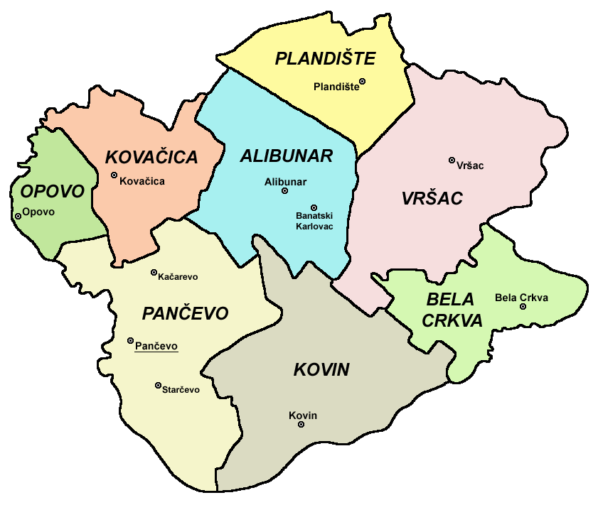
The South Banat District includes:
1. City of Pancevo - urban settlements: Pancevo, Starcevo and Kacarevo,
2. City of Vršac,
3. Municipality of Kovin,
4. Municipality of Kovačica,
5. Municipality of Alibunar - urban settlements: Alibunar and Banatski Karlovac,
6. Municipality of Bela Crkva,
7. Municipality of Plandište,
8. Municipality of Opovo.
Ethnically and religiously, this is one of the most heterogeneous regions in Europe. Serbs are predominant, but there are also significant numbers of Romanians, Hungarians, Slovaks, Macedonians and Roma, while Bulgarians, Germans, Albanians, Bosnians, Vlachs, Gorans and Bunjevacs are represented in a somewhat smaller number. Good interethnic relations and tolerance are traditionally nurtured in the South Banat District.
There are 121 registered cultural assets on the territory of South Banat: 89 are cultural monuments, 2 are territorial cultural-historical complexes, 27 are archeological sites and 1 is locality of importance.
Some of the cultural monuments are:
• Vojlovica Monastery from 1405, Pancevo,
• Church of the Assumption and Transfiguration from 1811, Pancevo,
• National Museum (located in the building of the Magistrate built in 1833),
• Town Hall in Vrsac (Magistrate) from 1860,
• Vrsac Castle (Vrsac Fortress, Vrsac Tower) is a fortress from the 15th century,
• Bishop's Palace in Vrsac (built between 1750 and 1757),
• Remains of the medieval fortress Old Town, Kovin,
• Serbian Orthodox Church in Samos, Kovacica,
• Wells in Vladimirovac, Alibunar,
• Serbian Orthodox Church of Saints Peter and Paul, Bela Crkva
• Jagodic Castle, Plandiste,
• Serbian Orthodox Church of St. Nicholas, Opovo.
There are 23 protected natural assets in the South Banat District, of which 1 protected habitat, 1 memorial natural monument, 2 landscapes of exceptional features, 1 nature park, 5 natural monuments, 11 natural monuments, 1 special nature reserve and 1 strict nature reserve.
The largest protected area in the district, with an area of 34,829.32 ha and located in the territory of the municipalities of Alibunar, Vršac, Bela Crkva and Kovin, is the Special Nature Reserve "Deliblato Sands" (protected in 2002). It is positioned between the Tamis River, the Danube and the Bela Crkva valley, and represents the largest oasis of sand-steppe and forest vegetation that once dominated the Pannonian plain.
The landscape of exceptional features, Vrsac’ Mountains, represents a separate geomorphological unit. It is located in the southeastern part of Banat along the border with Romania. Most of the mountain massif is located within the borders of Serbia, while a smaller part of it is in Romania. The highest peak of the Vrsac’ Mountains is Gudurica Peak (641 m a.s.l.), which is also the highest peak in Vojvodina. The Vrsac’ Mountains belong to the municipality of Vršac territory. Protection was established in 2005, on an area of 4,371 ha.
In the City of Pancevo are:
• Ponjavica Nature Park
• Natural monument "Black poplar tree in Uljma"
• Natural monument "Ivanovo Ait"
• Natural monument "Two white ash trees near Dolovo"
• Natural monument " Curcin’s chestnut in Pancevo"
• Natural monument "Red-leaved beech tree in Omoljica"
• Strict nature reserve "Ivanovo"
In the City of Vrsac are:
• Protected habitat "Small Vrsac Marsh"
• Memorial Natural Monument "Memorial Forest in Kustilj"
• Landscape of exceptional features "Vrsac’ Mountains"
• Natural monument "Bernatsy herbarium"
• Natural monument "Large-leaved linden"
• Natural monument “Mulberry Avenue no. 2 (Zagajica-Izbiste)
• Natural Monument „Mulberry Avenue No.3 (Izbiste-Uljma)
• Nature monument "Guard"
• Natural monument "Old park in Vlajkovac"
• Monument of nature "City Park in Vrsac"
In the municipality of Bela Crkva is:
• Landscape of exceptional features of Karash-Nera
In the municipality of Plandiste are:
• Natural monument "Jagodic Castle Park"
• Monument of nature "Old Park in Veliki Gaj"
• Natural monument "Castle Park in Hajducica"
In the municipality of Alibunar is:
• Natural monument "Park in Alibunar“